About me
Hi, I’m Robin. Welcome to my website 🎉
I’m a Professor of Transport Data Science at the University of Leeds Institute for Transport Studies(ITS), where I undertake research, develop software and web applications, and teach data science for evidence-based transport planning.
Here you can check out my publications and previous/upcoming talks, with links aplenty to visual/audio/video content that you can read/listen/watch to in your own time 📖🎧📺 I share lots of code for data science and reproducible research, this could be a good place to find resources to get started and try out things if you’re interested in reproducing or building on some of the work that I’ve done (which in turn builds on the work of others as all research does). I also occasionally share blog posts and other things here. If you’d like to get in touch, see here 🚀
I lead the Transport Data Science module, which is available to ITS Masters students and MSc students at the University of Leeds taking Data Science and Data Analytics and Data Science and Urban Analytics courses.
You can find me on various platforms, including Mastodon, Google Scholar, and GitHub.
- Geocomputation
- Transport modelling
- Reproducible geographic data analysis
- Mode shift, especially uptake of active modes
PhD in Transport and Energy, 2013
University of Sheffield
MSc in Environmental Science and Management, 2009
University of York
BSc in Environmental Geography, 2008
University of Bristol
Upcoming & Recent Talks
Featured Publications

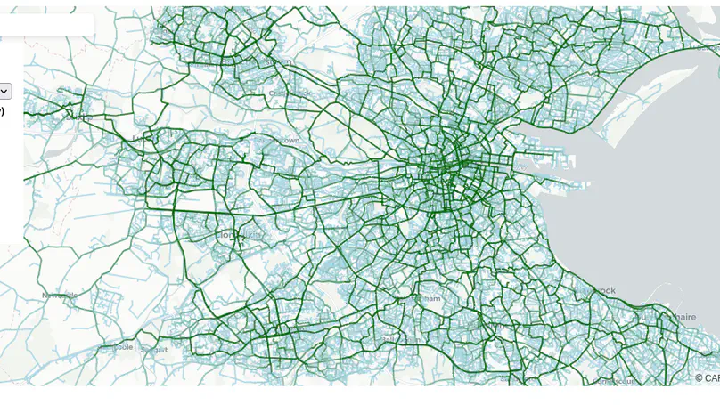
This paper describes an approach for developing strategic cycle network planning tools. Based on our experience developing and deploying the Cycle Route Uptake and Scenario Estimation (CRUSE) Tool for Ireland, we outline the underlying methods, including disaggregation of origin–destination data with the open source ‘odjitter’ software, incorporation of additional trip purposes, routing, scenario generation, and development of an intuitive user interface that is tested and used by practitioners. Commissioned by the national infrastructure agency Transport Infrastructure Ireland, CRUSE provides estimates of current and potential future cycling levels under ‘snapshot’ scenarios to inform investment decisions. The publicly available results at https://cruse.bike/enable planners, engineers, and other stakeholders to make more evidence-based decisions. CRUSE goes beyond previous work by: modeling networks at high spatial resolution; simulating multiple trip purposes (social, shopping, personal utility, recreational, and cycle touring), supplementing official origin–destination datasets on travel for work and education; and providing estimates of ‘quietness’ (a proxy for cyclist comfort and route preference) at the route segment level. Three network types—‘Fastest’, ‘Balanced’, and ‘Quietest’—help plan both arterial and residential cycle networks. Workshops with stakeholders were used to inform the development of the tool. Feedback shows that the tool has a wide range of uses and is already being used in practice to inform urban, inter-urban, and rural cycle network designs. The approach is flexible and open source, allowing the underlying ideas and code to be adapted, supporting more evidence-based and effective cycling policies and interventions internationally.
Recent Publications
Recent Posts
Skills
80%
90%
100%
Experience
Responsibilities include:
- Cycle uptake modelling
- Software development
- Deployment
Responsibilities include:
- Project Management
- Data analysis
- Modelling
Contact
Feel free to get in touch in using the form below. It may be worth considering contacting me in other ways, however, including:
- On GitHub, by commenting on an existing issue or discussion or creating a new one.
I put this one first not because I love the world’s premier code-sharing side (although I do ♥) but because I get a lot of software questions. For example: “I have got xx, data, can I get xx outputs using one of your tools?” It’s good to see these questions but often a most appropriate to ask in an open forum such as GitHub or StackOverflow, because:
- You’re likely to get a response quicker
- Other people can benefit from your answer (see here for a good example of how to ask a good question on GitHub)
- I prioritise well-asked questions, ideally with a reproducible example, over vague questions sent directly to me
- On Discord, a great place to ask questions about methods and technology. You can join the Geocompr Discord Server and ask questions here:
- In a comment below one of the pages on this website. See the bottom of this page for an example of this in relation to the Propensity to Cycle Tool (note: you need a GitHub account to add comments in this way, as you do to ask questions on GitHub)
- On social media where I can be found, hopefully with the aim of increasing the signal-to-noise and light-vs-heat ratios on such platforms
- Via my work email address which you can find online if it’s directly related to my work


