The problem: Proprietary GIS software

Solution: Open Source Software for Geocomputation

![]()

Geocomputation with R
Open source + open access book: https://geocompr.robinlovelace.net/
Chapter 1: History
Foundations
- Starting from nothing
- Class definitions
- Spatial/attribute operations
- Projections
- Data IO
Extensions
- Advanced methods
- How to build your own functions
Applications
- A taster of what you can do
Future directions of travel in FOSS4G
Future directions of travel in FOSS4G
- Integration (e.g. R package qgisprocess, R/Python crossover)
- New approaches, e.g. GeoRust
The problem - Transport

Source: 'Inside the black box' report
- Transport models were designed to support growth in car ownership and reduce journey times (Boyce and Williams, 2015)
The problem - Transport
Source: 'Inside the black box' report
Transport models were designed to support growth in car ownership and reduce journey times (Boyce and Williams, 2015)
21^st^ Century priorities are very different
The problem - Transport
Source: 'Inside the black box' report
Transport models were designed to support growth in car ownership and reduce journey times (Boyce and Williams, 2015)
21^st^ Century priorities are very different
- Climate science, air pollution and health force a shift in focus
- The concepts of 'participatory democracy' and 'citizen science' mean there is a need for collaborative solutions
The solution - Transport
New technologies mean that open access transport models are possible
 Source: A/B Street, free, open source, gamified transport planning software github.com/dabreegster/abstreet

From open source to open access

- Transport models represent a leverage point in transport systems
- New paper, Lovelace et al (2020) describes the emergence and possibilities for 'open access models'
What is science?
- Scientific knowledge is hypotheses that can be falsified
- Science is the process of generating falsifiable hypotheses and testing them
- In a reproducible way
- Systematically
What is science?
- Scientific knowledge is hypotheses that can be falsified
- Science is the process of generating falsifiable hypotheses and testing them
- In a reproducible way
- Systematically
- Falsifiability is central to the scientific process (Popper, 1959)
- All of which requires software conducive to reproducibility

User support
Getting help is vital for leaning/improving software

User support
Getting help is vital for leaning/improving software
"10-Hour Service Pack $2,000" (source: caliper.com/tcprice.htm)
From prototype to deployment
- Example: the Propensity to Cycle Tool (PCT.bike) (Lovelace et al. 2017)
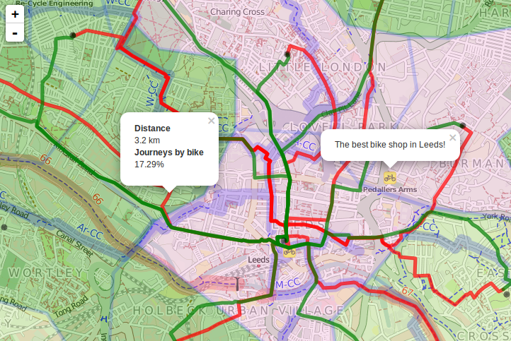
Visualising data
A fundamental part of data science is being able to understand your data.
That requires visualisation, R is great for that:
plot(desire_lines)
- Interactively:
library(tmap)tm_shape(desire_lines) + tm_lines("all")Checking the results:
b = c(0, 25, 50, 75)tm_shape(car_dependent_routes) + tm_lines(col = "percent_drive", lwd = "all", scale = 5, breaks = b, palette = "-inferno")

Thanks
Contact me at r. lovelace at leeds ac dot uk (email), @robinlovelace
Check-out links to my work at robinlovelace.net
Thanks to everyone building a open and collaborative communities
Thanks to the University of Leeds and the Institute for Transport Studies
