class: center, middle, inverse, title-slide # ActDev Project ## Actionable Evidence Supporting Active Travel (and Decarbonisation) in the Planning System ### Robin Lovelace, Joey Talbot ### Leeds’
Institute for Transport Studies
and partners ### ActDev Workshop, 2021-12-07 (updated: 2021-12-07) Reproducible source code:
github.com/cyipt/actdev
--- <!-- Talk in context: --> <!-- 1 hr in total, 15 min talk by Robin, 15 demo by Joey, 30 min questions + answers --> <!-- https://www.eventbrite.co.uk/e/evidence-to-support-active-travel-in-the-planning-system-tickets-211640180477 --> <!-- 20 minutes Q & A on the ActDev tool --> #### The problem (source: Garden Villages and Garden Towns report, [TfNH](https://tps.org.uk/news/tfnh-report-on-garden-villages-and-garden-towns)) Photo: Bicester Eco Town <a data-flickr-embed="true" href="https://www.flickr.com/photos/transportfornewhomes/49995904016/in/album-72157714662617023/" title="Bicester 3"><img src="https://live.staticflickr.com/65535/49995904016_3848a910c0_h.jpg" width="1600" height="1200" alt="Bicester 3"></a><script async src="//embedr.flickr.com/assets/client-code.js" charset="utf-8"></script> <!-- ![](https://user-images.githubusercontent.com/1825120/103755051-1b6b2f80-5005-11eb-988b-f7c8d3108e53.png) --> <!-- Source: ['Inside the black box' report](https://www.co.pierce.wa.us/DocumentCenter/View/755/A-GuideToModeling?bidId=) --> ??? This housing estate in Bicester illustrates the problem: it's called the Bicester Eco-Town so you'd be forgiven for thinking that it has a low environmental impact A picture can tell a thousand words but it still can be deceptive: we need a more objective view of things --- #### Marketting vs Reality ![](https://www.willmottdixon.co.uk/asset/11080/crop/1428/768) Source: [Willmott Dixon](https://www.willmottdixon.co.uk/projects/north-west-bicester-eco-town) ??? When planning officers are presented with a proposal it is often difficult to evaluate sustainability claims Guidance and objective measures are scarce, meaning that intuition is often used What we need is an object evidence base --- background-image: url(https://user-images.githubusercontent.com/1825120/144555764-b085f647-6448-459a-84f5-4fc947ac2f43.png) background-size: contain #### Data driven evidence (source: [https://actdev.cyipt.bike/bicester/](https://actdev.cyipt.bike/bicester/routenetwork,buildings/#9.75/51.9082/-1.2006)) <!-- ![](https://user-images.githubusercontent.com/1825120/144555764-b085f647-6448-459a-84f5-4fc947ac2f43.png) --> ??? Why are housing developments being approved in places like this at a time of climate crises? --- # Demand for housing ![](http://researchbriefings.files.parliament.uk/documents/CBP-7671/assets/b1a30d07-0fd0-4e31-88b3-fee717bbea88.png)<!-- --> Source: Tackling the under-supply of housing in England, [House of Commons Research Briefing Jan 2021](https://commonslibrary.parliament.uk/research-briefings/cbp-7671/) --- ## Policy and research context ![](https://user-images.githubusercontent.com/1825120/144556770-80237854-00d1-4211-bad5-bd5c3d478a1a.png)<!-- -->![](https://user-images.githubusercontent.com/1825120/144557012-d11d36cf-88e1-40ff-81a8-8e60de017510.png)<!-- --> -- - Tensions between vital policy objectives of [housing](https://commonslibrary.parliament.uk/research-briefings/cbp-7671/)/[levelling up](https://www.gov.uk/government/news/new-homes-to-be-built-as-part-of-government-drive-to-develop-brownfield-land-and-regenerate-communities) vs [decarbonisation](https://www.gov.uk/government/publications/transport-decarbonisation-plan)/[active travel](https://www.gov.uk/government/publications/gear-change-one-year-on-review) -- - Transport models were designed to support growth in car ownership and reduce journey times (Boyce and Williams, 2015) -- - Few tools for assessing active travel potential or provision in/around new developments (Megan Streb MSc) -- <!-- - Yet tools for transport planning and development are based on old priorities --> ??? Governments must meet multiple competing objectives The August 2020 planning white paper outlined the need to create beautiful places and provide housing A House of [Commons Research Briefing](https://commonslibrary.parliament.uk/research-briefings/cbp-7671/) from January 2021 outlined the challenge of increasing housing supply to meet the aim of building 300k houses per year The July 2021 Decarbonising transport paper set out dramatic policies for the sector with rapid uptake of walking and cycling: "We will aim to have half of all journeys in towns and cities cycled or walked" And in the 2021 Gear Change one year on policy paper, the prime minister said in the foreword "I support councils, of all parties, which are trying to promote cycling and bus use. And if you are going to oppose these schemes, you must tell us what your alternative is, because trying to squeeze more cars and delivery vans on the same roads and hoping for the best is not going to work." As we've seen the problem is largely political but it has has a substantial technical component The 'tools of the trade' - Climate science, air pollution and health force a shift in focus - The concepts of 'participatory democracy' and 'citizen science' mean there is a need for collaborative solutions Despite substantial academic work on integrated land-use transport models and an entire academic journal dedicated to it Planning and transport not always joined up --- ## The ActDev tool 4 month UKRI funded project on high impact research in transport/planning Publicly available tool with maps and data on active travel levels, potential and provision ![](https://user-images.githubusercontent.com/1825120/110671502-79afbc80-81c6-11eb-9dc5-52046b1d04c8.gif) --- ## Levels of analysis ![](https://user-images.githubusercontent.com/1825120/110673378-9ea52f00-81c8-11eb-9822-58d44e1ecae2.png) --- #### The ActDev Team: agile, reproducible, open data science and software development ![](https://user-images.githubusercontent.com/1825120/110677777-75d36880-81cd-11eb-8c59-eb406066bc4a.png) -- ![](https://user-images.githubusercontent.com/1825120/110678305-0e69e880-81ce-11eb-98aa-7d91fd71e81c.png) ![](https://user-images.githubusercontent.com/1825120/110678068-ca76e380-81cd-11eb-8dec-f191dfe708b6.png) --- ## Feedback from workshop <blockquote class="twitter-tweet"><p lang="en" dir="ltr">This is absolutely glorious and I and many others were simply astounded when we saw it at that workshop on Friday. <br><br>Go and have a look if you're involved in urban design and place - you won't regret it. <a href="https://t.co/1hlxMM5MO1">https://t.co/1hlxMM5MO1</a></p>— Kit Allwinter (@KitAllwinter) <a href="https://twitter.com/KitAllwinter/status/1372976668604829696?ref_src=twsrc%5Etfw">March 19, 2021</a></blockquote> <script async src="https://platform.twitter.com/widgets.js" charset="utf-8"></script> <!-- ![](https://user-images.githubusercontent.com/1825120/110797848-79203000-8271-11eb-80be-99b8d7abcec5.png) --> --- ## Stakeholder mapping - Professional planners: Lynda Addison, Lead on planning and transport integration, Transport Planning Society - Active travel planners: Julian Sanchez, Active Travel, Programme Manager, Essex County Council, Kit Allwinter, Active Travel Officer West Yorkshire Combined Authority - Consultants, e.g. Lucy Taussig, Consultant, Active Travel - Local Authority Planning Officers - NGOs, e.g. Megan Streb, Partnership Manager, Sustrans - The wider public --- ## Research findings - Median distance to town centre is 3.2 km only three within 2.0 km - **14%** of trips made by active travel in the areas surrounding the 35 sample site locations - Provision of good infrastructure varies considerably Source: Academic paper under review (Talbot et al. [2022](https://osf.io/7fuq5/)) ![](https://user-images.githubusercontent.com/1825120/144582516-fb32cf82-aeb3-4ff5-810c-02095bb6eb2c.png) --- ## The importance of open data and open tools ![](https://www.robinlovelace.net/publication/lovelace-open-2020/featured.png) - Transport models have a huge impact on transport planning - More people with access to good data -> better outcomes ??? - New paper, Lovelace et al (2020) describes the emergence and possibilities for 'open access models' --- ## Possible next steps .pull-left[ - Review of stakeholder needs, engagement with relative parties, e.g. DfT, DLUHC, [BEIS](https://www.gov.uk/government/organisations/department-for-business-energy-and-industrial-strategy), [CCC](https://www.theccc.org.uk/), the nascent [Active Travel England](https://www.gov.uk/government/news/338-million-package-to-further-fuel-active-travel-boom), local authority planning officers, and more - Additional data sources - Improve modelling to include more explanatory variables - Refine treatment of walking - Additional trip purposes - Scale up nationally - Training, outreach, maintenance ] .pull-right[ ![](https://user-images.githubusercontent.com/1825120/110936020-26557f80-8328-11eb-9b1f-39dd73640962.png) ] ??? Extra data sources N. car parking spaces --- # Community feedback Source: the ActDev code repository's [issue tracker at github.com/cyipt](https://github.com/cyipt/actdev/issues) ![](https://user-images.githubusercontent.com/1825120/144586091-1324e0b3-836d-4144-ba52-5e65eea70732.png) ??? Our open source and agile development process allows anyone to suggest additions We have already added three more sites following popular demand, there is demand for more --- ## Planning applications nationwide Location of 100k+ 'large development sites' Analysis is work in progress ![](https://user-images.githubusercontent.com/1825120/110936020-26557f80-8328-11eb-9b1f-39dd73640962.png) <!-- ## Using the tool to assess site location --> <!-- ![](https://user-images.githubusercontent.com/1825120/110680440-85a07c00-81d0-11eb-9658-7f303e72372f.png) --> <!-- ??? --> <!-- Trip patterns --> <!-- - Add images showning trip/distance/mode splits --> <!-- - Great Kneighton --> <!-- - Wynward --> <!-- --- --> <!-- ## Using the tool to assess (and improve) walking and cycling routes --> <!-- ![](https://user-images.githubusercontent.com/1825120/110777119-ad3b2700-8258-11eb-87f9-553449faa757.png) --> <!-- ??? --> <!-- Joey --> <!-- - Busyness levels --> <!-- - Circuity --> <!-- - Great Kneighton vs Upton --> --- # 
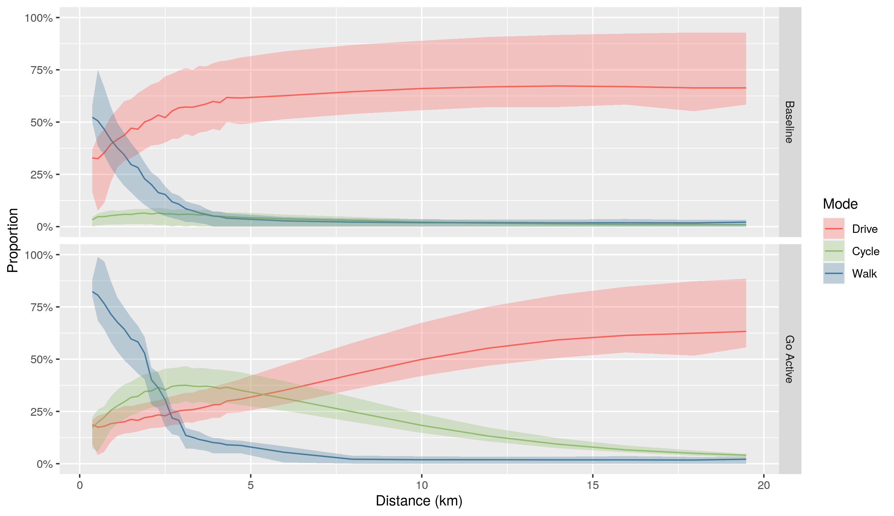
Modelling change: scenarios ![](https://raw.githubusercontent.com/cyipt/actdev/main/data-small/scenario-overview.png) --- ## Site level data ![](https://user-images.githubusercontent.com/1825120/110680440-85a07c00-81d0-11eb-9658-7f303e72372f.png) --- ## Core ActDev Layers See https://actdev.cyipt.bike/manual/ ![](https://user-images.githubusercontent.com/1825120/110682147-876b3f00-81d2-11eb-96e9-b86203ec250e.png) --- ## Contextual layers ![](https://user-images.githubusercontent.com/1825120/110693965-f4390600-81df-11eb-8d7a-c37ea0e23f1f.png) --- ## The A/B Street tool ![](https://user-images.githubusercontent.com/1825120/110777940-9d701280-8259-11eb-9c17-c56f5b709c83.gif) --- ## Live demo of the tool ![](https://user-images.githubusercontent.com/1825120/110671502-79afbc80-81c6-11eb-9dc5-52046b1d04c8.gif) --- # References Boyce, D.E., Williams, H.C.W.L., 2015. Forecasting Urban Travel: Past, Present and Future. Edward Elgar Publishing. Beimborn, E., Kennedy, R., 1996. Inside the Blackbox: Making Transportation Models Work for Livable Communities. Citizens for a Better Environment. Lovelace, R., Parkin, J., Cohen, T., 2020. Open access transport models: A leverage point in sustainable transport planning. Transport Policy 97, 47–54. https://doi.org/10.1016/j.tranpol.2020.06.015 --- # Thanks Thanks to the University of Leeds' LSSI, the Institute for Transport Studies, UKRI and the Department for Transport [![](https://avatars3.githubusercontent.com/u/22447619?s=400&u=2d566bedf62374d5066a50d2dd7c87c84470f69b&v=4)](https://environment.leeds.ac.uk/transport) --- ## The ActDev Questionnaire ![](https://user-images.githubusercontent.com/1825120/110797354-e5e6fa80-8270-11eb-8b9d-26b2ac1c0403.png) Your feedback will help improve our work